Pisac Inca Ruins

The Inca ruins at Pisac are strategically placed high on the promontory that overlooks the eastern end of the Sacred Valley.
Pisac is known as the “fortress of towers” due to the numerous towers built throughout the complex. It is the perfect place to keep a lookout over the Sacred Valley and one of the main access routes to Cusco.
The Inca constructed their cities in the shape of an animal and Pisac was built in the shape of a bird. (Cusco is a puma). The name Pisac comes from the Quechua word pisaq or p’isaqaq which is the name of an Andean partridge. It was an important bird in Andean symbolism and is even present in the Andean constellations in the Milky Way. (You can see a great painting of the Andean constellations in the Qorikancha in Cusco).
Directions for how to get there by car or on foot are at the end of this blog. If you’re coming to Peru you need my travel guide app. Peru’s Best is the only app you need to plan a trip to Peru. Download Peru’s Best for iPhone or Android!
The ruins were built during the reign of the Inca Pachacutec.
During the 15th century, the Inca Pachacutec built an incredible number of cities, including Ollantaytambo and Machu Picchu. He also significantly expanded the city of Cusco and built the Qorikancha.

Arriving at the ruins
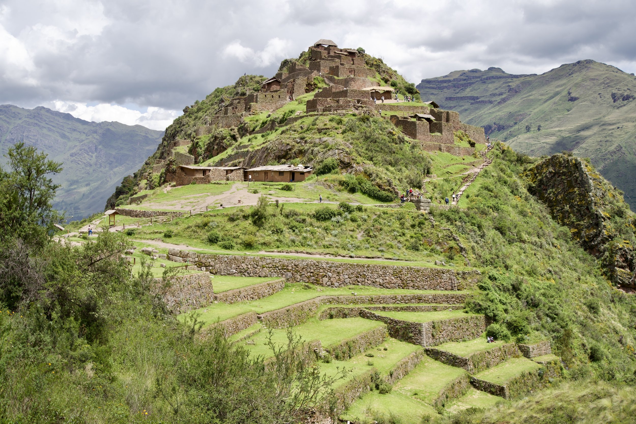
When you first arrive at the ruins, you’ll see the Incan signature wide agricultural terraces, with the remains of buildings on the hilltop.

Looking back at the entrance
These are the same terraces as above, but seen from the buildings on the hilltop.
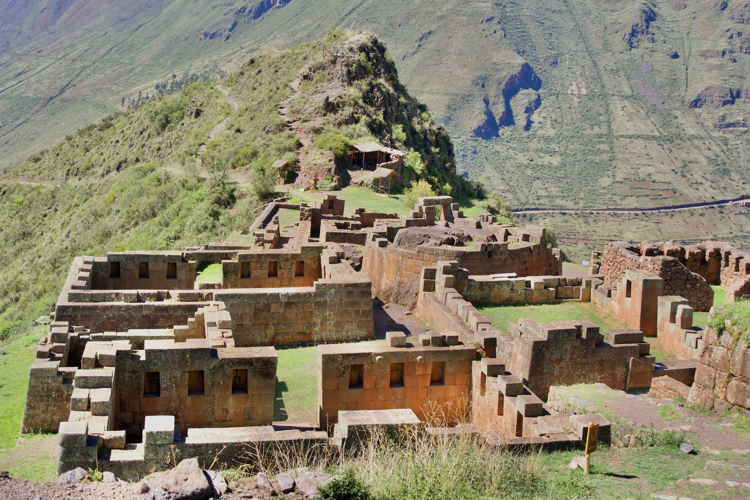
From behind
These small terraces are below the fountains and baths. The buildings on the hilltop are the same as in the first photo. Standing in the same spot, just to the right are the tombs.
The whole area is over two miles long and contains several distinct sections. Starting from the top (assuming you arrived by car) you will first see the terraces, hilltop ruins, cemetery and fountains. They are divided into five sections: K’alla Q’asa, Qaschis Raqay, Tianayuc, Intiwatana, and Pisaq’a.
K’alla Q’asa is the largest group of buildings, situated on the hilltop in the photos above, facing the main terraces.
Qaschis Raqay is a group of buildings that overlooks the stream below the cliff of tombs.
Tianayuc means “contains a seat” and it’s a small group of buildings around a central space that has what appears to be a stone sofa.
Intihuatana is the ceremonial center, about a 15 to 20 minute walk downhill from K’alla Q’asa.
Pisaq’a is a semicircle of ruins which served as a guard post halfway up to the Pisac ruins from the Urubamba river and modern town of Pisac. Scroll through the photos at the bottom of the blog for a picture of Pisaq’a.

Cliffside of tombs
Often called the biggest known Inca cemetery, this cliffside is full of holes of looted tombs. The Inca buried their dead mummified and bent into the fetal position. Unfortunately, all of the tombs at Pisac were looted by the Spanish when they invaded and destroyed Pisac. The ruins themselves
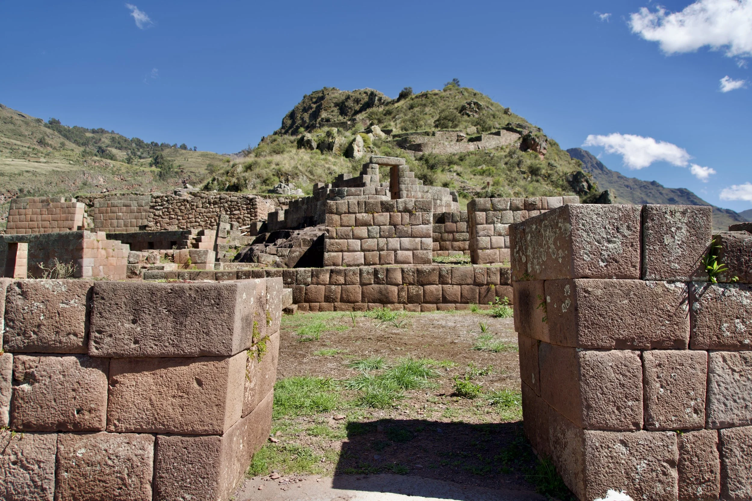
The Intihuatana
Intihuatana translates to “place where the sun attaches to the earth” and there are hundreds of intihuatanas in Peru. The most famous are at Machu Picchu, but the one at Pisac is much bigger and more complete than what you can see today at Machu Picchu. An intihuatana is a piece of bedrock that is partly carved but partly left as nature made it - which is what makes them so sacred. They were believed to be places where the sun attached to the earth, without any real need for humans to modify the natural stone.
This is the most important part of the ruins, which most tourists never get to see! You need half an hour to walk down the crest of the hill to see the ceremonial sections which includes the intihuatana, quarters for the ñustas, temples and observatory. The typical group tour of the Sacred Valley gives you an hour for Pisac - just enough time to see the terraces and buildings on the hilltop, as well as the cliff of tombs and the fountains and baths.


How to get there by car
You can always book a tour, but if you want to get there on your own, first go to Calle Puputi in Cusco. (It’s only a 15 minute walk from the main plaza). There are lots of vans and cars for Pisac with prices from s/8 to s/12 per person. You’ll be let off at this bridge at the entrance to the town of Pisac.
Just across the bridge, there is a taxi stand that has cars up to the Pisac ruins. The last time I checked, the price was s/30 per car, so if you have a group it’s a better deal. You can turn right at the corner and walk a couple blocks to where there are other taxis who might take you up to the ruins. They’re usually cheaper but you’re not guaranteed that somebody will agree to drive all the way up.

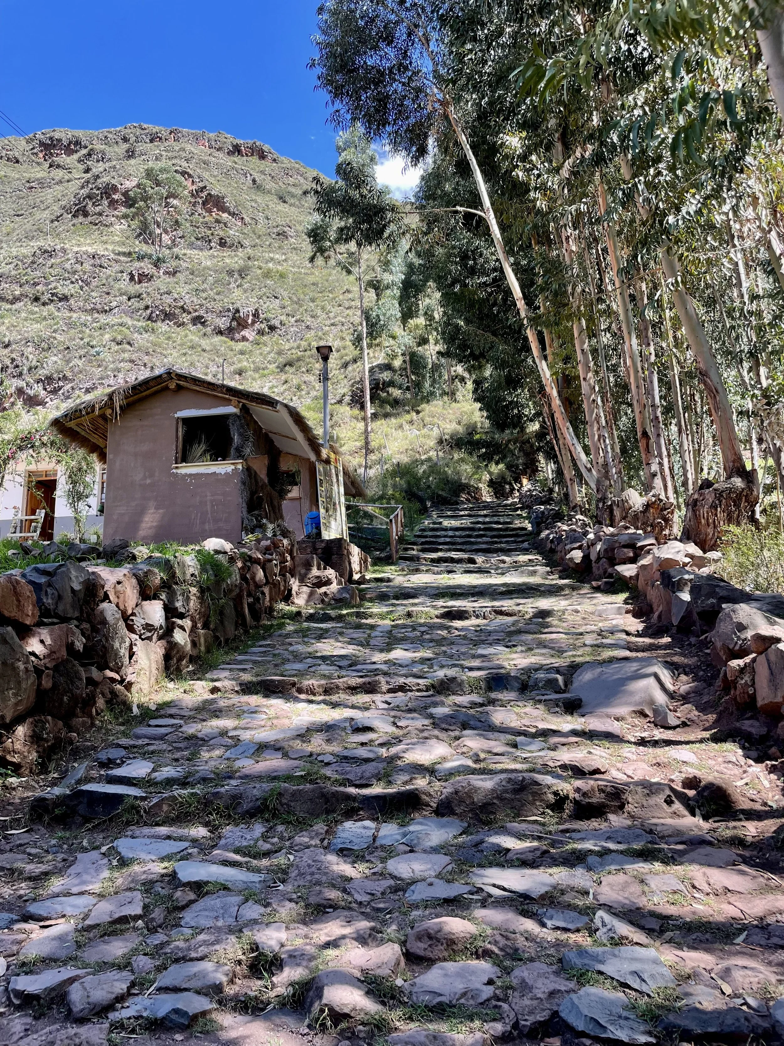
How to get there walking
When you arrive at the bridge (above) keep walking through town, away from the river and towards the hills. The main plaza is only four blocks from the bridge and anybody can direct you there. Facing the church in the plaza, go to the lefthand corner and keep walking uphill. You’ll pass the artisanal market of souvenirs before you arrive at the wooden arch in this photo.
The photos below are in the order that you’ll see places as you walk from the town up to the ruins. The trail is well marked with arrows and in some place alternate trails are closed with wooden gates, so you really can’t wander off on the wrong path. There are a few benches built along the way to rest and you will cross a small wooden bridge. You’ll pass lots of terraces, some of which are still farmed. You’ll also pass the half-circle ruins of Q’allaqasa, which were a guard station halfway between the Urubamba River and the Pisac ruins. You’ll arrive at the downhill end of the ruins, by the Intihuatana. This is the part that most tourists never see - because they arrive by car and only have an hour to see the top half of the ruins.
The town is at 9,680 feet above sea level (2950 m) and the ruins are at 10,827 feet (3300 m) - so be ready for the trail to be all uphill! You can also take a taxi up to the ruins and walk back down to town.